This web page shows a virtual hike of the Superior Hiking Trail (SHT) in real time. The hikes are organized from south to north, beginning at the Minnesota-Wisconsin Border and ending at the 270 Degree Overlook which is near the Minnesota-Canada Border. I have organized the videos to align with the official SHT website. For up to date maps, parking and the current status of the SHT, visit that website.
Since the videos on this web page were taken at a specific moment in time, what you see in the video may no longer be accurate. The videos were taken during all seasons of the year, so just like the real SHT, conditions will change from section to section.
| |
Sections are shown from South to North |
| Length |
Campsites |
|
Section Name: MN/WI Border to Duluth |
Links to all of the Campsites in this Section |
| 1.9 miles |
One |
|
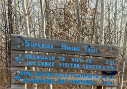
MN/WI Border to the Wild Valley Road TH |
Red River Valley |
| 5.9 miles |
In State Park |
|
Wild Valley Road TH to the Jay Cooke State Park Visitor Center |
High Landing (state park campsite) |
| 5.9 miles |
Zero |
|
Jay Cooke State Park Visitor Center to the Grand Portage TH |
|
| 4.1 miles |
Zero |
|
Grand Portage TH to the 131st Avenue West TH |
|
| 2.4 miles |
Zero |
|
131st Avenue West TH to the 123rd Avenue West TH |
|
| 4.1 miles |
Zero |
|
123rd Avenue West TH to the Magney Sniveley TH |
|
| 1.8 miles |
Zero |
|
Magnew Snively TH to the Spirit Mountain TH |
|
| 3.4 miles |
Zero |
|
Spirit Mountain TH to the Waseca Street TH |
|
| 2.3 miles |
Zero |
|
Waseca Street TH to the Skyline Parkway TH |
|
| 5.5 miles |
Zero |
|
Skyline Parkway TH to the North 24th Avenue West TH |
|
| 1.5 miles |
Zero |
|
North 24th Avenue West TH to the Twin Ponds TH |
|
| 4.0 miles |
Zero |
|
Twin Ponds TH to the Duluth Rose Garden TH |
|
| 4.4 miles |
Zero |
|
Duluth Rose Garden TH to the Hartley Nature Center TH |
|
| 3.0 miles |
Zero |
|
Hartley Nature Center TH to the Martin Road TH |
|
| |
Length |
Campsites |
|
Section Name: Duluth to Two Harbors |
Links to all of the Campsites in this Section |
| 6.8 miles |
Two |
|
Martin Road TH to Lismore Road |
Bald Eagle, White Pine |
| 6.9 miles |
One |
|
Lismore Road to the Normanna Road TH |
Lone Tree |
| 8.1 miles |
Two |
|
Normanna Road TH to the Western Fox Farm Road TH |
Heron Pond, Sucker River |
| 4.1 miles |
One |
|
Western Fox Farm Road TH to the Eastern Fox Farm Road TH |
Fox Farm Pond |
| 6.4 miles |
One |
|
Eastern Fox Farm Road TH to the Rossini Road TH |
Big Bend |
| 5.6 miles |
Two |
|
Rossini Road TH to the Lake County Demonstration Forest TH |
McCarthy Creek, Ferguson |
| 9.7 miles |
Two |
|
Lake County Demonstration Forest TH to the Reeves Road TH |
Stewart River, Reeves Falls |
| 5.4 miles |
One |
|
Reeves Road TH to Lake County Road 301 |
Silver Creek |
| |
Length |
Campsites |
|
Section Name: Two Harbors to Silver Bay |
Links to all of the Campsites in this Section |
| 6.3 miles |
Zero |
|
Lake County Road 301 to Castle Danger |
|
| 8.0 miles |
Five |
|
Castle Danger to Gooseberry Falls State Park |
Crow Valley, East Gooseberry, Middle Gooseberry, West Gooseberry, Gooseberry |
| 6.9 miles |
One |
|
Gooseberry Falls State Park to the Split Rock River Wayside Rest |
Blueberry Hill |
| 3.8 miles |
Four |
|
Split Rock River Wayside Rest Loop Trail (rest stop trail to state park) |
SW Split Rock R., NW Split Rock R., NE Split Rock R., SE Split Rock R. |
| 10.6 miles |
Three |
|
Split Rock River Wayside Rest to Town of Beaver Bay (incl. section above) |
Chapins Ridge, Beaver Pond, Fault Line Creek |
| 4.4 miles |
Two |
|
Town of Beaver Bay to the Town of Silver Bay |
North Beaver River, South Beaver River |
| |
Length |
Campsites |
|
Section Name: Silver Bay to Caribou Falls State Wayside |
Links to all of the Campsites in this Section |
| |
|
|
|
|
|
| |
Length |
Campsites |
|
Section Name: Caribou Falls State Wayside to Lutsen |
Links to all of the Campsites in this Section |
| |
|
|
|
|
|
| |
Length |
Campsites |
|
Section Name: Lutsen to Grand Marais |
Links to all of the Campsites in this Section |
| |
|
|
|
|
|
| |
Length |
Campsites |
|
Section Name: Grand Marais to 270 Degree Overlook |
Links to all of the Campsites in this Section |
| |
|
|
|
|
| |
|
|
|
|
| |
|
|
|
|
|
|
 |